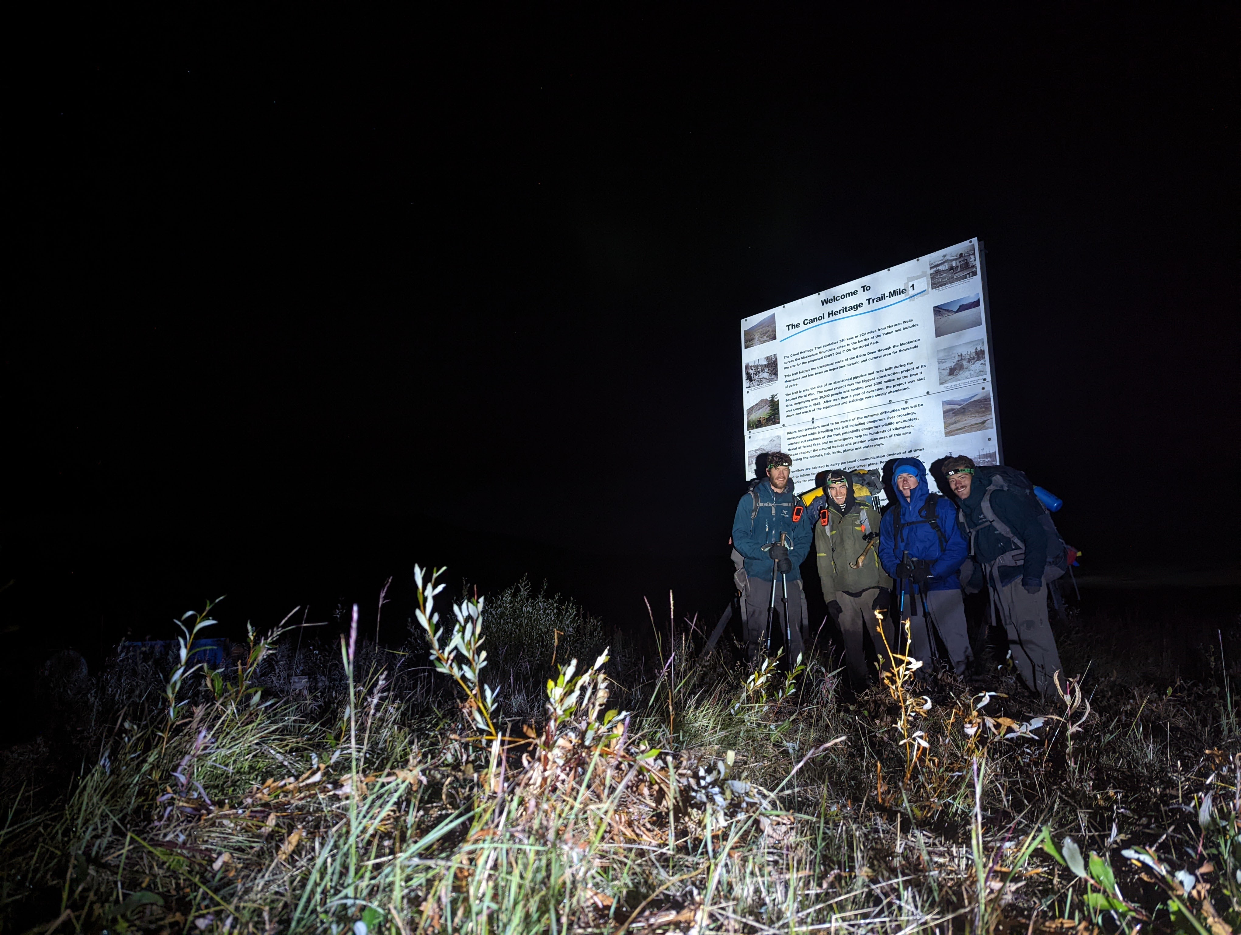
Canol Heritage Trail August 2022
Log Entry : August 15th : Day 9 : 1036 : ‘Stacy’s mom does indeed have it going on’
230km from our starting point on the sandy bank of the Mackenzie River, ailing greatly from the previous 8 days of trekking through untamed Mackenzie Mountain wilderness, Tucker and I had just spent the last 30 minutes improvising a news segment covering eyewitness reports that Stacy’s mom has got it going on. With another 150km ahead of us, we were in that mental grey area where nothing really makes sense, and nobody said it had to.

I suppose a bit of history is order so one can understand why the heck a group of four hooligans ended up deep in the impossibly remote Mackenzie Mountains of the Northwest Territories, following faint roadbed dotted with scraps of run down sheds and rusted machinery:
The Canol (Canadian
Oil) road was initially developed as a pipeline by the US military to access Norman
Wells oil prospects during WWII, however after 2 years of construction
requiring 30000 workers and costing roughly $300 million ($5.5 billion today), it
was put into operation for just 13 months before the war ended, and the
pipeline was abandoned. Almost immediately after that, the Canol road became
impassable to vehicles. The rugged Mackenzie Mountains wanted nothing more than
to return to their natural state it seems, as all the bridges and much of the
road were quickly washed out, and dense vegetation overtook what was left.
Although the road on the Yukon side was eventually maintained for the hunting
and mining exploration it supports today, the Northwest Territories (NWT) side
beyond the small hunting camp of Canol Outfitters has seen little, if any, maintenance since 1945. The heritage
trail, which starts at MP (Mile Point) 0 in Norman Wells, NWT, and ends at a
little airstrip and outfitter staging area at MP 222, now falls within the
boundaries of the proposed Doi T’Oh Territorial Park as part of the Sahtu Dene
and Metis Land Claim Settlement. Remediation efforts may continue for some time
before the park comes to fruition, but the trail is still in the Sahtu Dene and
Metis traditional territory so hikers and hunters visiting the land should show
respect to the environment and people of this region. The earliest records I
can find of hikers and backpackers attempting the traverse are in the 90’s but
I am sure people, especially Sahtu Dene locals, were on the route long before
that.
 |
| Pump Station MP 36 |
In the grand world of North America’s long distance hiking trails, the roughly 370km long (depending how lost you get) Canol Heritage Trail has repeatedly been named amongst the most difficult, which, if I’m being honest, is something I read about only just now while writing this. The walking itself isn’t technical at all, there’s no scrambling or dangerous exposure, but there are some other things that make the Canol especially daunting:
The river crossings can be a bit sketchy - there’ve been a few fatalities in these rivers - the most recent that I’m aware of on the trail was in 2016 when a man drowned trying to cross the Little Keele. Most parties on the trail with any sort of safety margin carry packrafts. We relied on one raft for the four of us to save weight and ferried across each river.
The Mackenzie Mountains host a relatively high concentration of grizzly bears. I had my own standoff with curious grizzly along Godlin River and we heard an account of a bear attack in a similar spot where the hiker attributed their survival to the rifle they were carrying. We didn’t carry a gun although many locals said we were crazy to go without.
Your feet stay wet the entire trail. Let the blister prone be warned, creek crossings and swamp stepping are spread so rampant as to keep your sneakers nicely saturated. This is especially true if you are trying a faster than average pace. With patience and time to spare you may be able to keep dry feet through some sections by changing shoes for each crossing but that’s not always practical. Make sure you have shoes that you can walk in with wet feet.
The trail is quite remote. If something goes wrong, your first response may not come for many hours, if the weather even permits a helicopter flight, and it will likely be a dispatch from Canol Outfitters of a small helicopter carrying one or two hunting guides with basic first aid and little to no rescue equipment. If a river crossing goes awry, it could be days before a swift water team is able to respond. If you do end up needing rescue, you’ll pay an arm and a leg (if you still have ‘em) as these operations aren’t government funded in NWT.
All that said, if you do your research, make sure you’re prepared, and anticipate a dose of suffering, you’ve got a pretty good chance of making it out the other end. And what the hell if you decide to give up part way it’s only a $5000 helicopter ride to Norman Wells.
 |
| A map of the trip I put together with route data from Anthony DeLorenzo. Full resolution version: https://photos.app.goo.gl/oMiokc91pvb1MVNw6 |
 |
| Cramming gear into the truck |
The 4 of us long legged boys haggardly jigsawed ourselves into my little access cab truck. We weren’t particularly looking forward to the cramped 12 hour, inevitably farty, drive from Whitehorse to Mile Point (MP) 222, most of which follows a bumpy hunting road (the North Canol Road) that winds northeast from Ross River into the foothills of the Mackenzie Mountains. That morning we’d been delayed by fanatic group discussion after getting news from the trail. We’d heard from a party attempting the trail before us that they had turned back after one member was swept off her feet by high water and strong currents in Dodo Canyon. To our knowledge, they were just the second team to attempt the trail this season. The first party, a solo bikepacker, had also turned around after encountering heavy fire smoke earlier in the summer. We eventually pulled out of the driveway at 1330, beneath stormy skies, and turned onto the highway which would take us north to Ross River where the long bush road began.
 |
Driving the North Canol to MP222 |
August 7th : 'Looking for avgas jerry cans. We lost Digby! Finally taking off at 1315'
The next
morning, we sat in silence, huddled in the cramped truck to escape the rain, on
the side of a small gravel airstrip. MP 222, where we were parked, would be the
end point of our hike. From here, we’d fly a bush plane to Norman Wells (MP 0) and
walk the ~370km back to the truck. A faint drone broke the silence, I rubbed a
hole in the condensation and peaked outside – plane! We burst open the doors,
clambering over each other to un-jigsaw ourselves from the truck cab.
 |
| Gerd (our pilot) and Tibo standing in a puddle. |
We had a weight limit of 1000lbs for the plane and were worryingly close to that number at our last weigh in. We made sure to dump out all our water before loading up to shave some weight. Tucker, however, had the clever idea to drink his water to shave the weight instead of dumping it out… good one Tuck. Once we’d loaded up, Gerd, our pilot, buzzed to the end of the runway. After pointing us into the wind, he kicked it into high gear and we started gaining speed down the rocky airstrip, his first attempt to get off the ground only bounced us back onto the runway – we were heavy, I glared at Tucker, he didn’t look parched at all. We continued to speed down the airstrip, two more unsuccessful attempts and a good dose of bouncing later we finally left the ground.
 |
| Tucker got the front seat and I'll forever hold a grudge for that |
 |
| At the trailhead after taking a boat across the Mackenzie. |
After a boat crossing from Norman Wells, the western shore of the Mackenzie River was all laughs and smiles. A break in the rain and the excitement of starting the trail was a recipe for high spirits, and we started walking at 1615. High spirits certainly softened the blow of the Mackenzie Death March – a 35km swamp tromp that separates the Mackenzie River from the Mackenzie Mountains. Immediately after leaving the sand, dense willow pops up and smacks you across the face. By the time you get 20 steps through the feisty foliage you realize you are lost. After the disheartening realization that it took less than a minute before you had to use the gps, you’ll be best to start running. Hordes of mosquitos flatten any desire to stop in the Mackenzie Death March, plus the thought of running out of clean water in this land of giardia is a good motivator.
We had no hopes of crushing the 35km on our first day with a 1615 start, so we settled into a little cabin on Heart Lake for the night after walking 13km in the rain. Before bed us four boys stalked around the hut in just our briefs to rid the space of mossies; thuds of successful hunts peppered the otherwise quiet room.
 |
| Heart Lake Shelter, built fresh in 2020 |
August 8th : 1310 : ‘The sun is shining on our swampy endeavor. A couple more hours until we leave this place. Will I miss the swamp? No definitely not but toss me in a pale and smack me across the face if I ever say I don’t feel amazing tromping through deep boreal muck’
We belted Katy Perry’s ‘Firework’ in the warmth of the morning sun as we packed up for the day. Although we’d been warned of chest deep swamp through this section, the only person who took a plunge past their knees was myself after a misstep plopped me waist deep in a muskeg stream. The other boys giggled their way across as I shamefully crawled up the muddy bank. 20 some odd kilometers later, the Carcajou River appeared before us at 1600, braiding across its wide, rocky canyon. Naively, we slumped our packs down, removed most of our clothes and lounged in the sun. We had just 10km left to make that day, how long could that possibly take?
 |
| Good lookin group of guys if I ever saw one - Carcajou |
Two and a
half hours after reaching the shore of the Carcajou and we still hadn’t
traversed the mere 500m wide canyon. Tricky route finding through the fast-moving
currents of each new channel and some raft shenanigans had slowed our pace to a
crawl. Having just one raft between the four of us, we’d prepared a shuttle
system where one guy paddles to the far side with his bag and somebody holds a
tag line on the near side. When he reaches the far side, he secures the paddle,
and the boat is pulled back to the near shore by the tag line so the next guy
can go rinse and repeat. Crossing one of the final channels of the Carcajou, Tucker
had just crossed, leaving me on the near shore by myself to pull the boat back.
Tibo pushed the boat off and into the current. As I pulled on the tag line I
expected it to catch the boat within a couple pulls but three, four, five yanks
on the line went by and the boat hadn’t caught. It started picking up speed in
the current. Confused, I yelled ‘are you sure it’s attached?’ Digby looked up
from his bag and, with wide eyes, spun on his heels, galloped like a gazelle
across the rocky shore and jumped into the river after the boat. A hero lunge
was the difference between retrieving the raft and having to end the trip right
there, and a hero lunge is what we got from our knight in shining armor Digby.
We’d foolishly trusted a non-locking carabiner to keep the tag line on the
raft, and it had popped open.
 |
| Still Crossing the Carcajou hours later |
 |
| Dodo Canyon in all its glory |
 |
| Camp spot in Dodo Canyon |
Although we got an early start, anticipating a long day, the northern sun was high when we broke camp. A weather update told us an evening low pressure system might dump 20mm of rain, and we feared the power of the Little Keele if the rain beat us there. Our goal was to push the 36km to the Keele and get across it that evening before the rain hit.

 |
| Dodo Canyon Lake |
Pushing on
from the lake, we started up Whore Hill, the final obstacle between us and the
Little Keele. We stopped for dinner at 2020, only part way up the long ascent. Our
pace had slowed dramatically as Digby’s blisters had taken on a new, meaner
persona. Any hopes of making the 14km remaining between us and the Keele were
quickly fading, and the storm was quickly growing. Dinner gave new life to Tuck
and I, and we set off towards the summit, ahead of the other boys, with a
determined pace. Rain and cloud swelling around us didn’t dampen our high
spirits as we giggled our way up the hill. We didn’t realize the distance we’d
put between us and the other boys until we popped out on the summit, getting
blasted in the face with fierce, icy winds. The new chill broke our giddy state,
and we came back to reality, realizing the situation. Digby had now fallen far
behind with nasty blisters, the weather was baring its teeth, we still had 9km
to the Keele, and our light was fading as my watch read 2300. We’d freeze if
not get blown off the mountain if we tried to set camp at this elevation in the
current conditions. We huddled out of the wind to wait for the other boys, and,
once regrouped, the plan was a quick consensus: set camp as soon as possible. Making
our way down from Whore Hill was a frantic search for a camp spot in the
darkening storm. The hummocky boreal forest around the trail fostered no place
to sleep and the trail itself was steep enough to dash any thoughts of staking
our shelter. Finally, after close to an hour of stumbling through rain and wind
and struggling with frozen hands trying to set a bear hang, we slid into our
damp sleeping bags on a small piece of flatter roadbed for the night. The 34km
we’d walked felt like a failure, and I slept restless, worrying what the Keele
had in store as the rain poured down on our sagging tarp shelter.
August 10th
: 0930 : ‘Dig and his dead man’s pack. If you saw him walk, you’d think he was
the dead man himself’
 |
| The Keele |
A break in the rain at 0800 saw us frantically packing our gear to get moving and we charged off towards the Keele, Digby hobbling along behind. By 1030 we had eyes on our obstacle. It didn’t take long before we’d found a good crossing spot and were setting up the raft system. The 20mm of precip overnight hadn’t swelled the river as much as we’d expected. This river is not wide, maybe 20 metres; its ferocity, however, comes from the deep, fast moving current. The 2016 fatality on the trail was in this river and we could see how being swept downstream would be bad news. We set up every safety system we had and then, one by one, pushed off into the fast water. Tibo was the last to paddle the Keele and a great sigh of relief was in order when we all stood safely on the other side. As if the weather was synchronous with our emotion, the skies began to clear, revealing newly snowcapped peaks above.
From the Keele, our trail started to climb towards Joker’s Ridge. This section of trail gave us our first taste of stunning high elevation views through the Little Keele drainage and across the Mackenzie Mountains. The sun beamed down on our newly energized team as the trail wound along steep mountainsides, revealing idyllic, meandering streams and a colorful wetland below, teeming with bird life.
 |
| View from Jokers Ridge |
 |
| Our magical sunset. Tibo looks like he's pooping but I can assure you he is not, that would certainly have made the sunset slightly less magical. |
August 11 : 2142 : ‘WE FOUND THE FOOD DROP HALLELUJAH NO MORE RATIONING!’
 |
| No lack of antler finds on the trail |
Making only 28km the day before, we were falling behind
pace so Digby, still in crocs, left camp early to get a head start while we
finished packing up. Easy walking the day before had our hopes up for good
roadbed again. It took just a couple hours before we abandoned any hopes for
easy trail, however, as we were soon navigating ankle breaking boulders when
the trail disappeared into endless washouts and dense brush. Finally breaking
out into the upper Keele drainage by 0800, we sat for breakfast beneath brilliant
blue skies. Although the route ahead lacked any sign of trail but this wide
drainage offered a beautiful new landscape of rolling alpine ridges above open,
U-shaped valleys.
We each tackled the long, tiring boulder thrash at our own pace. That meant, when a herd of caribou trotted out onto the river bed around us, working their way seamlessly through the boulders and across the river, we, together, experienced the encounter alone. When we eventually regrouped farther up the valley, we each shared how special that encounter was, and our admiration for the creatures didn’t wear off through the many more encounters we had as we continued up the valley.
 |
| Keele Valley |
Regrouping again at the MP 76 Pump Station, a collection of old buildings and rusted machinery from the pipeline, we were sun baked and sore from stumbling through boulders and creeks all day. It was just 1630 and we were keen to keep moving up to the Plains of Abraham that night but there were risks. The Plains are the highest elevation section of the Canol at 1756m, well above the freezing level at night and, if we were caught in a storm up there, we’d either be chased away by fierce winds and/or buried in snow. On the other hand, there was the possibility of a food restock up there. The party that turned around in Dodo Canyon had dropped two pales of food from the airplane above the Plains that they said we could take if animals didn’t get to them already. Our slower than expected pace thus far had forced us to reduce our rations to just 3000 calories a day (down from 3500) as we were anticipating an extra couple days on the trail, so the chance of food tonight was beyond tempting for us hungry boys. We pressed on into the alpine.
 |
| MP 76 Pump Station |
 |
| Finding the food cache |
 |
| Sleeping at RM Camp MP 80 on the Plains of Abraham |
As hard as
it was to leave the sleeping bags in the morning of our frozen alpine camp, we
were happy to not be buried in snow as we climbed out to another day of blue
skies. A few hours of gallivanting through the stunning high elevation plateau
in the morning brought us to the high point of the trail at 1756m. High fives
all around and a group poop amongst the rocks was our celebration for the
milestone, then we started down the long descent to Andy Creek.
 |
| Plains of Abraham |
I looked back at the steep scree slope above; I’d have broken my legs if I tried that but there’s Dig for ya. He waved around a toothy grin, so proud of himself.
 |
| Crossing Andy Creek, Plains of Abraham in the background |
We regrouped to cross Andy Creek, a shallow but fast-moving crossing, and Dig showed us his shoe situation. After walking 80km in crocs, the soles had worn through and he’d been forced back into his hikers. To reduce the pain, however, he’d cut the sides open so his pinky toes were hanging out. Not even halfway through the trail, it seemed a bold move to already be dissecting his only remaining pair of shoes.
 |
| Tucker and I on the roadbed route |
 |
| Digby and Tibo's tussock route |
Another 8km of easy walking up the Carcajou and a simple river crossing later, we reached Carcajou shelter, sun burnt and sore. A successful day, we were happy to have made our target 33km in a reasonable time. Before drifting off for the night I wrote ‘thank the wildlife for the maintaining the trail’. The massive grizzly tracks, intertwined with wolf and caribou prints provided insight for what the Canol had in store in the coming days.
 |
| Carcajou shelter |
Perched high on a hilltop above the Carcajou, the shelter became a sauna in morning sun. A quick breakfast and we set off up the valley towards Devils Pass. Delightful walking brought us along an alpine creek, through caribou dotted grasses, and over boulder ridden washouts. On our way up, we spotted a momma grizzly bear and her cub rolling amongst blueberries just above the trail. Being downwind of the pair, we admired them for some time without them noticing. When we decided to keep moving, we reluctantly set off a bear banger and they darted off into the boulder field above.
 |
| Up the valley towards MP 108 Pump Station |
Around midday, we caught a glimpse of the MP108 Pump Station that marked our entrance into Devils Pass. The four of us walked together, making movie references and cracking mediocre jokes as we approached the old buildings when, simultaneously, we hushed our chatter. There was another person walking amongst the buildings. I looked around at Digby, who was just behind me, it couldn’t be him this time.
We’d been
told by our bush pilot, Gerd, that there was one other party on the trail, coming
the opposite direction. They had started walking a couple days before us.
Although we’d expected to run into them at some point, it remained a strange
experience seeing other humans, so far in the middle of nowhere. Once we got to
chatting with the pair of boys, the conversation just started pouring out –
neither party had seen new faces in some time. The boys promised us good
roadbed ahead, while we had to break to them the opposite news, and we sat for
an hour in the sun, discussing grand adventures of past, present and future. Regretfully, there is not one single picture of this encounter, who knows maybe we imagined the whole thing.
 |
| Ascending Devils Pass |
After parting with the friendly faces, we began the climb into Devils Pass. Our spirits soared to new heights and we soaked in our good fortune. Clear skies above, a recent food restock, and nothin but clean roadbed ahead was a recipe for euphoria. In our heightened state, we caught a glimpse of another grizzly, lumbering along the opposite hillside as we crested the pass and began our descent.
What goes up must come down, and we were pretty friggen high on life. Our glorious trail soon deteriorated into dense brush then, not long after, trail-less washouts hosting wobbling boulders and eroding riverbanks. Exhausted by our new terrain, we’d conveniently forgotten the other party had said mostly good roadbed ahead. We slumped down for dinner as dark clouds began swelling around us. I took off my sock, revealing a red, swollen ankle from repeated aggravation on an old injury in the rocks, Digby winced from his own new ankle injury, Tucker nursed his badly bruised shoulders, and Tibo catered to fresh blisters on the bottoms of his feet. What goes up must come down and we were falling hard.
 |
| Trout Creek hurt locker |
August 14th : 2300 : ‘Got through the Twitya and had din. Accidents happen, should communicate better next time’
After skirting our way through a mix of washout and overgrown roadbed alongside Trout Creek in the morning, we now had to cross the thing. It was clear we were getting used to these crossings as nobody batted an eye at the fast moving, thigh deep traverse over loose, slippery boulders. Once across, we set off with a fiery pace. An obvious rock feature resembling a rabbit perched high on a distant scree slope was fitting company for our newfound speed.
 |
| Stoke factor high, pain factor also probably high |
 |
| Crossing the Twitya |
At last, we approached what would be our most difficult river crossing of the trip, the Twitya. I’d read about it being wide and treacherous, and the boys we’d met on the trail had warned us of its ferocity, but it’s a whole different ball game when you a see it in person. Where the trail first meets the Twitya, the full flow is contained in one channel maybe 100m across. Our ferry system didn’t have the range to make that, so we bushwacked upstream into a braided section of the river where it was split into five separate channels, each 20-30m across. The first three channels were relatively straightforward, although we could tell each new crossing was getting progressively more dangerous. Looking at the 4th crossing, none of our options seemed particularly appealing and we settled on trying to paddle straight across the nearest section: a narrower, but fast-moving channel to a sandy spit. The worrying part was that nowhere in this channel was there slow-moving water, it was fast from shore to shore. This meant getting in and out on either side would be challenging, especially for the first and last paddler, who wouldn’t have someone to help with the transition on one end. I volunteered to go first, and the other boys started setting up the rope system while I packed the boat. There were some nerves as Digby crouched on the steep, sandy bank, holding onto me in the boat while Tuck and Tibo flaked out the rope above. Finally, they shouted ‘ready?’ over the rushing water, ‘ready’ I replied and Digby pushed me into the current.
I paddled furiously out the gate and made it halfway across until I felt a strong tug on the rear of the boat. As much as I tried to keep paddling, the rope had been caught on a willow bush and I was very quickly being swept downstream. After a few seconds the boys on shore, who were working frantically, got the rope untangled. Once freed, I could continue to paddle toward the spit on the other side. The problem now, however, was that I was so far downstream that I was running out of rope. I paddled hard but just a few meters from shore, I felt the dreaded tug again, I’d run out of rope. I tried to fight the tug, but I was only floating downstream and getting further away from shore. Realizing I would soon miss the sand spit, I stuck my leg into the fast water and started dragging it along the rocky riverbed, trying to find any kind of purchase. I immediately started taking on water, submarining the entire right side. As the raft flipped over, I grabbed hold of my bag and flopped towards the shore. I clawed my way onto the sandy spit and took a deep breath, I was furious. My frustration had to be put aside though, as there was a new situation that needed attention. The boys had thankfully been able to recover the capsized raft, but now I was on my shore with the paddle and they were on the other shore with the boat. Shouting over the water, a long debate took place that ended with Tucker volunteering to take the raft far upstream, which he would then hand paddle/float downstream without a tag line attached to meet me on the sandy spit. As Tucker bushwacked up the island, Tibo, Digby and I sat in silence on our respective shores, all safety systems ready, anxiously awaiting Tuckers signal. When he finally set off, Tuck did a fantastic job of hand paddling as he floated downstream and I was able to safely catch him on my spit. From there, I hopped back in the raft and paddled back across to reunite the boat with the tag line, and we continued the crossing as normal.
After
crossing the fifth and final channel with ease, we regrouped and had a chat
about what had happened. We agreed that the tag line should have been let go to
allow me to make it the last few meters to shore instead of holding onto it. We
were mostly just happy everyone was safe, and we hadn’t lost any gear. It had
taken us almost 6 hours in total to cross the Twitya, and, as we sat for dinner
on the far shore at 2300, we were thankful to have it behind us. After a short
meal we pushed on for another hour through bushy marsh to try and make up some
distance before setting camp on a dry patch in the dark.
 |
| Tucker's bum upstaging a sunset over the Twitya |
August 15th : 2030 : ‘Stinky muskeg ponds bringing sweet boreal muckories back’
The morning was a dance with willow as we ducked and bobbed along overgrown trail for hours. The endless mountain views we’d gotten used to were more sparing, but magnificent nonetheless, when we got glimpses through the brush. As we pressed on, the stench of muskeg became progressively more potent until, at last, we encountered our first ponds, and the entire valley of swamp opened before us. The trail repeatedly dove into deep ponds of muck, so we were forced to route find through the surrounding spongey, saturated sphagnum, peppered with decrepit spruce. It was a fantastic throwback to our days on the Mackenzie Death March
 |
| Ah yes, more squelching grass, how lovely |
Slowly, our swamp morphed into river and we charged on through easy trail. The washouts were simple to navigate, and the creek crossings straightforward. Despite our various ailments, we were stoked to be making good progress, and were leaning into the rhythm of the trail. Overcast skies and the promise of meal prepared by the Canol Outfitter’s camp managers the next day were factors in making the 32km we walked feel tame.
 |
| As much as you make 'vroom' noises I don't think it's gonna drive, Tucker |
August 16th : 1210 : ‘Lots of pain today but f*** it were goin. Jagged peaks line this drainage wowee’
A check in with my ankle in the morning was worse than I’d thought; It was swollen like a tomato, and any weight bearing was unpleasant. We pooled all the painkillers we had and rationed them out. I got one ultra-strength Tylenol and one regular strength Advil per day assuming we had 4 days remaining, not sure if that would cut it. We agreed to seek out a painkiller sponsorship for our next trip.
Once my ankle warmed up it started feeling manageable so I booted off ahead of the other boys, trying to make as much distance as possible while I felt good. After some time, I came across a section of flooded trail. It didn’t take long before I gave up trying to keep dry feet and sloshed my way through. I knew the other boys, who’d had more blister issues than I, would take their time trying to keep dry feet through it so I debated waiting for a moment. If I waited, however, that would mean my ankle would get cold, and I’d have to endure a terrible pain trying to warm it up again, so I reluctantly pressed on ahead.
Getting into a good rhythm, I was cruising along the overgrown trail, head down, when I turned a corner and the bushes beside me exploded in a flurry… a furry flurry. Stumbling over myself in shock I turned to see an enormous bear butt hustling up the bank away from the trail. A massive grizzly and I had spooked each other out of our wits. After getting over the initial scare, the grizzly stopped at the top of the bank and looked back at me. The bear then turned around and started walking towards me.
I didn’t
have bear spray, and I was far ahead of anyone who did. As I backed away from
the approaching bear, I reached for my bear banger. Although I was relatively
safe while there remained some dense willow between us, I was worried if he
pushed through the brush and onto the open trail he would charge. Continuing to
back away, I unzipped my hip pocket and fumbled through its contents, throwing
everything unnecessary onto the ground. The bear flattened the brush in its
path as it advanced, huffing aggressively. The grizzly was just a couple metres
from the open trail ahead of me as I shakily screwed on the banger and loaded
the device. I released the trigger and the banger soared high into the air
before detonating in a blast. The bear immediately stopped in its tracks, but
he didn’t seem entirely convinced to give up on me. I took several hurried
steps backwards and loaded another banger. The second banger did the trick and
my whole-body tense began to ease as he hoofed it in the other direction.
Several minutes later, having heard the bangers go off, Tibo came running
towards me, followed shortly by Tucker and then Digby. They’d all abandoned any
attempt to keep their feet dry and were splashing through the water furiously, worried
I’d been dragged off by a hungry griz. These studs showed up – wet feet, sweaty
and out of breath – ready to wrestle a grizzly bear for me. Nothing makes a guy
feel more special.
 |
| Tibo loving life en route to a home cooked meal at the outfitter |
After the encounter, the roadbed spit us out into an open Godlin river drainage. We paused shortly to take in the majestic landscape, before pressing on across a washout and towards our dinner at Canol Outfitters. Another, slightly less intense, grizzly bear and a river crossing later, and we were on the final stretch towards the Outfitter.
 |
| Canol Outfitters |
Our first taste of civilization after 10 days was punctuated by a slobbery guard dog named George. Navigating George’s valiant torment was a tall tale but the reward was a home cooked meal so we couldn’t be stopped. We plopped our sore asses in the sun out front the little Canol Outfitter cabin and stretched the day away while the only two camp inhabitants Glen, the camp manager, and Sierra, a camp helper, cooked us a meal that made us slobber like George. The other two, much friendlier, dogs, named Twitya and Keele, lay with us outside and we reminisced with them about our quarrels with their respective rivers. A couple more hours of walking after dinner took us to the Ekwi River where we set camp.


 |
| Onwards to the Ekwi |
August 17th : 1533 : ‘Tucker’s shirt is growing mold. It’s quite funny actually. Of course he’s still wearing it what the damn hell else is he gonna wear’
I had to
keep reminding myself the morning ankle pain was the
worst – it would only get better throughout the day – as I broke my painkiller
ration to try and find some sort of relief. I wasn’t the only one battling
a sore body though, everyone had their own knee or shoulder or blister related
ailment to deal with after 10 long days on the trail. My ankle did get better,
and pretty soon I was rocketing ahead of the boys once again, afraid to stop
moving. Alone at the front of the pack, I kept seeing and hearing things in the
dense willow that weren’t there – a product of my grizzly encounter from the
day before. The only wildlife encounter I actually had that day was a beaver
who very nearly scared the literal poop out of me when he slapped his tail in a
nearby pond.
 |
| Tucker Crossing the Ekwi |
The trail
follows the Ekwi up towards Caribou Pass, winding through a little rocky canyon
and spitting out into high peaks and dreamy valley views. Caribou Pass has some
of the most intruiging mountains of the entire traverse. Peaks of pitch black
with golden, green and brown streaks that line swooping rock bands and
crumbling cliffs make for a fairytale-like landscape. At the top of the pass, beneath
these peaks, a little hunting cabin sits on a creek which I was peaking into by
1900, still far ahead of the other boys. The clouds were rolling in fast at
this point, bringing with them howling winds and threatening heavy rain.
 |
| Looking towards Caribou Pass |
All the
boys made it into the cabin just before the approaching storm hit full force.
Fierce wind rattled the broken windowpanes and rain smashed down from above. Eating
dinner, we sat on the plywood floor hoping the structure would hold through the
night.
 |
| Hustling to the shelter while the storm builds |
August 18th : 1539 : ‘Alas, we ascend out of our final valley and onto the alpine meadow where we will catch our first glimpse of 222’
Setting off
from our fairytale cabin under overcast skies we had just 50km between us and MP222,
a distance we planned to cover over the next day and a half. Although the
prospect of finishing the trail was exciting, I wasn’t looking forward to
leaving the Mackenzie Mountains. I tried not to think of the end as we plodded
along ever-improving roadbed past a pile of rusted Canol trucks and towards the
Intga.
 |
| Caribou Pass |
The sun
came out for us by the time we made the Intga. This would be our second last
river crossing of the trip. Tuck and I remarked how we’d miss crossing rivers
in our daily lives after the trip, maybe we’d have to dunk our sneakers in an
icy bathtub each morning before work just to get that sensation again back
home. Belting pop songs with as much gusto as we could manage, Tucker and I
were living our best trail life after the Intga until the distant drone of an
engine cut us off. Up the trail a big-wheeled side-by-side was bumping down the
rocky trail towards us.
 |
| Rusty barrel jam sesh |
Dechenla
Lodge came into view by 2030 and we stopped for food by a little pond. We’d
made 33km already and, as we sat around dinner shivering in the cold air, the
idea of pushing the last 17km to the truck loomed over us all. We were hurting,
Tucker especially was having knee troubles, but we didn’t know how long our
weather window would last and it could be nice to finish while the skies were
still clear.
 |
| Mackenzie Mountains Barrens |
Our
backdrop for dinner was a section called the Mackenzie Mountains Barrens. It is
recognized by the NWT government as a special wildlife area because it is home to one of the highest
densities of grizzly bear populations in the Mackenzie Mountains. The
Barrens take the form of a unique tundra meadow that spreads out almost
completely flat for 10km or more in all directions before jutting up into steep
peaks. Walking through it truly feels like you are traversing the eye of the
Mackenzie Mountains.
 |
| The trail between MP 222 and Dechenla lodge is driven by ATV somewhat regularly |
By sunset at 2300, we still had 10km remaining. Tucker was reluctant to push his knee more than he already had so we gathered to make a decision under the darkening sky. Tibo and myself were both in favor of walking through the night and finishing the trail and Digby was quickly coming around to the idea. The temperature was approaching zero and any wind in the Barrens would make for a miserable night in the tarp shelter, we also knew our weather window would close tomorrow so we may wake up to rain or even snow. A consensus was finally reached in the last light. Tibo, Digby and I each packed Tucker’s gear into our bags to take his load off and we walked on. “Heck maybe we’ll see the northern lights” I said, trying any angle to comfort Tucker in his reluctance to keep moving. We hadn’t yet stayed up late enough to experience the few hours of true darkness in August so there hadn’t been a chance to catch the aurora.
 |
| Sunset on the Barrens |
We had to
keep moving under the starry sky to keep warm. A couple unexpected creek
crossings doused our feet and made my toes numb in the below zero temperature, but none of
us could be bothered trying to keep dry feet at this point. Then, dragging my
feet through a section of ankle-deep swamp, I stopped for a moment and looked
upwards for the first time in a while. A faint streak of light hung above us in
the night sky. I splashed my way to the other side yelling at the other boys to
look up and see the aurora above us. The show, however, was only getting
started.


The final hour and a half of our Canol Heritage Trail was punctuated with “WOW!” and “look look look!” and “that’s the most amazing thing I’ve ever seen”. The northern lights morphed into flowing rivers and dancing columns and swirling streams that lit up the entire sky with greens, yellows and pinks. It’s impossible to describe the emotions that came together that night as we took our final steps to MP222, finishing the trail arm in arm while singing “The Final


Comments
Post a Comment